How could I get to the summit of Mount Hermon? They said I didn’t need to go, they said it was generally ‘out of bounds’, they said it was a ‘restricted area’. Who were they? My bosses at the United Nations whom along with the Israelis controlled access to the summit.
Inspired by the Robert Frost poem, The Road Not Taken, I resolved to pursue my own path to get to the summit of Mount Hermon. As per the sentiment of Frost’s poem, I found that to gain this new experience, I needed to be prepared to be unconventional and to be willing to be challenged. That was my pathway to growth.
This story is part of our Walking, Hiking and Meaningful Routes series. Read more here.
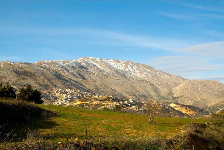
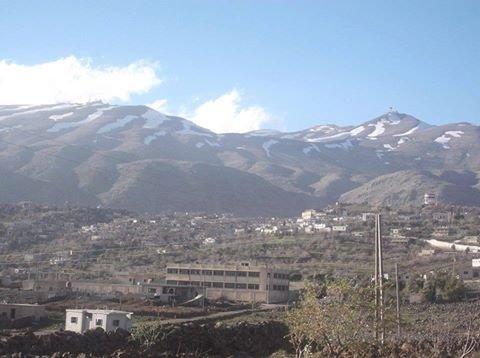
It was May 1992 when I first came under the spell of Mount Hermon, the highest point in the Anti-Lebanon Ranges. With a patchy covering of snow, fast winds swirling around and a wind chill factor occasionally approaching zero degrees Celsius, I was in the shadow of Mount Hermon for a seven-day stint serving as a United Nations Military Observer at UN Observation Post 71. I looked at its immenseness to my north every day, regularly, before turning my attention west to the foothills to perform the mission I was there to do – observe for violations of the Ceasefire Agreement between Syria and Israel. Being a ‘restricted area’, I could look at but not photograph Mount Hermon. It gave impetus to a desire to get to the summit.
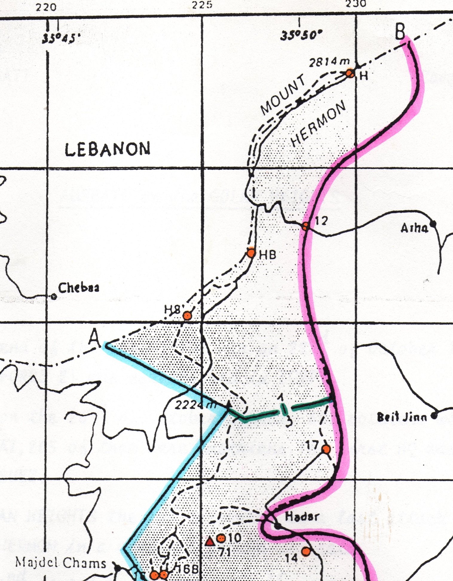
Mount Hermon was the dominant feature overlooking the northern half of the Golan Heights from a lofty 2,814 metres. It sat on the legal border between Lebanon to its north and Syria to the south, but since 1974 the Syrian side of the Mount was included in an Area of Separation between Israel and Syria, controlled by the United Nations. There was to be no military from either nation inside this Area. That is why I was there, part of the controlling United Nations force. I worked alongside the armed United Nations force that responded to any reported violations of the Agreement. After nearly 20 years of peace, the primary violators were local Syrian shepherds who occasionally grazed too close to the Israelis, crossing a line drawn on the map that regularly prevented them from accessing the next patch of lush green pasture for their sheep.
Mount Hermon had two peaks – the other was at 2,380 metres – with a saddle in between. I read in Moshe Dyan’s brilliant biography, Story of My Life (1976), that Israeli paratroopers captured both peaks in the last hours of the 1974 Yom Kippur War, thus gaining significant strategic advantage. By 1992, they had built an electronic surveillance station on the lower peak – with the capability to listen to everything that the Syrians were doing from the Area of Separation all the way to their capital, Damascus; about 52 kilometres to the north-east. Hence the descriptors ‘out of bounds’ and ‘restricted area’ in relation to the summit.
During my week of observing in May, I discovered that members of the armed United Nations force that I worked alongside would undertake regularly programmed foot patrols in the Area of Separation. It was not normal that unarmed Observers like me accompanied them. Here, I thought, was an opportunity to be unconventional and perhaps get myself closer to the summit of Mount Hermon. Not just because it was a mountain, therefore it needed to be climbed. No, Moshe Dayan’s book had given further impetus, I wanted to see the battlefield from the Yom Kippur War. I wanted to walk the ground, see the conditions the paratroopers fought in, see from the top how the Mount physically dominated the Golan. It was sure to be spectacular, perhaps I would be able to view Damascus!
I volunteered to join a foot patrol heading north towards the Mount. I was not sure how far up we would go, but it was half a day’s effort; nothing ventured nothing gained. With uniform and dusty Army boots on, I rugged-up with several layers. We started at 7.00 am at United Nations Position 17. The two-man patrol I joined was led by an Austrian Army soldier; he introduced me to a popular Austrian expression … ‘there are no kangaroos in Austria’. I knew that, but in the spirit of international cooperation laughed along with the Austrians. We headed north, past a minefield. With the occasional snow, effects of altitude and a less than gentle slope – and assiduously sticking to the narrow tracks through the minefield – the going was quite slow for the first hour.
Then, cutting across our path were several well-worn tracks coming down from Mount Hermon into the Area of Separation and towards Beit Jinn. I was advised they were smugglers trails from Lebanon. We subsequently saw dozens of smugglers with their robust mules on the various trails bringing large quantities of stores of all kinds into Syria. The Austrians observed but otherwise ignored them as they had no mandate to interfere; and there appeared to be no effort by the Syrians to prevent their activity. We continued to slowly climb, the air was getting thinner, my boots were encrusted with snow, which was becoming more prevalent. An hour later we paused, the views south, east and west were superb, then we turned around and headed back down. We had reached around 2,100 metres, well short of the summit. Being unconventional had not completely succeeded.
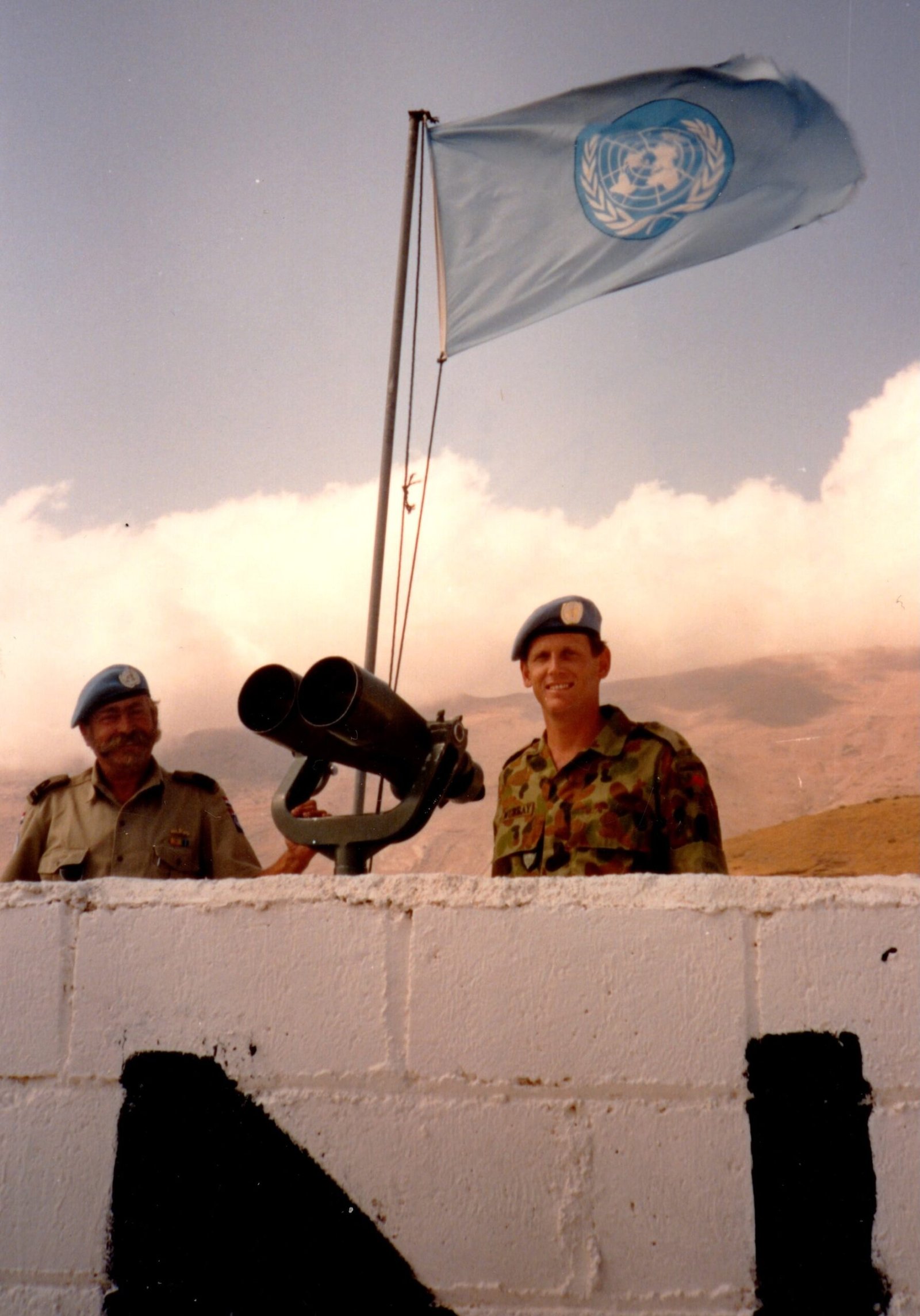
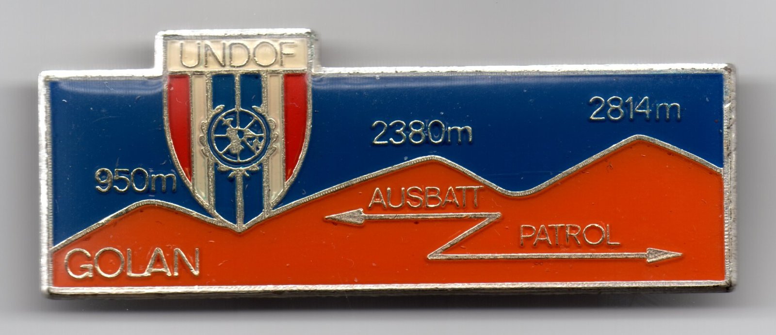
Two months later another opportunity arose, but it involved a personal challenge. A two-day trekking activity, arranged by the Austrian Battalion (AUSBATT), that commenced in the centre of the Area of Separation and ended at the summit of Mount Hermon. Brilliant! There were 150 places on the trek, once again it was not normal that unarmed Observers like me participated, but I signed-up and was accepted and secured leave from observation duty.
We started on a Saturday, in the second week of July, from the centrally located AUSBATT camp. Day One was the prelude to the main event, the initial challenge was to walk north towards Mount Hermon, in the process covering 17 kilometres mainly along black basalt tracks through patches of grass. We passed a few sheep. The weather had warmed considerably since May. Some found it hot, it was just pleasant for me, I walked with sleeves rolled up, enjoying the sunshine. There were a variety of internationals from the United Nations, I walked with an Irishman, Mike, and spoke to Canadians as well. The Austrians kept us well provisioned with food and drinks along the way. It was over relatively flat ground with some small hills towards the end as the Mount got closer; it was a straightforward undertaking. By late afternoon we stopped, we only climbed about 400 metres in elevation. I felt well and enjoyed a good night sleep under cover at United Nations Position 10, I was right next door to Observation Post 71 at about the 1,300-metre level.
Day Two was an early start; reveille was 3.45 am for a 4.45 am step-off. It was crisp, but the sunrise over Syria was spectacular. I wore warmer clothes to reach the summit at Position H via the road and past Positions HS and HB. It was a long day’s trekking, a real challenge – a total of 24 kilometres – including a lot of traversing over real mountain goat country with frequent stretches straight up. The basalt rock gave way to a large green belt in the foothills. After 3½ hours we reached the road, the vegetation thinned considerably. Then the real effort began; 14 kilometres along the winding road to the summit, nearly always climbing.
If you enjoyed this article, you might like Allan’s account of his travels on the Sandakan Death March route.
At the 8-kilometre mark, Mike and I were making good time. Often it was quite steep. But the last six kilometres on road was a real struggle. I was exhausted, and my right foot was quite painful from blisters; a sealed road will do that. It was even steeper than earlier, and every step was a painful effort. Despite this I had a good look around the battlefield I was walking through. I was impressed by the efforts of the Israeli paratroopers given the terrain, by now steep and rocky. Mike finished ahead of me; I finished at 7 hours. A hard day’s effort. I climbed 1,500 metres – the views were spectacular, the relief immense. I got to the summit of Mount Hermon, sadly I couldn’t see Damascus. But the view over the largely desolate, basalt and grass covered Golan Heights was majestic.
The Austrians gave me a badge to mark the achievement. In the subsequent years I found that very few Australians had done the two-day trek, so I was in a small group of Australians who had been to the summit of Mount Hermon. In 2019, I donated my badge to the Australian War Memorial, and they gratefully accessioned it into the Memorial’s collection, see AWM2019.766 (.1 to .6). I had experienced snow, smugglers, Austrian soldiers, surveillance stations, sheep and stunning sunrises. By being unconventional, I had grown as both an Observer and Army officer through my experiences. I had conquered the spell that Mount Hermon had over me and walked the battlefield from the Yom Kippur War. Is it possible for others to do it today from the south? Not yet. But there is hope, peace in the Middle East seems closer now than it has for decades.

I am a former Army officer and logistics specialist. In retirement I write articles and books ranging across military and naval history, biography and anthropology, which I publish through various association newsletters and websites and on Amazon. I live in Sydney.
[…] you enjoyed this article, you might like Allan’s account of his ascent of Mount Hermon in the Middle […]